
Lycian Way Walking Program
This program is designed to offer a more accessible and structured way to experience the Lycian Way. Instead of long-distance trekking with changing accommodations, the journey is based in Fethiye, allowing guests to return to the same hotel each evening.
Each day follows a different section of the route, combining natural trails, coastal views and traditional settlements. With organized transfers and a professional guide, the experience focuses on walking, scenery and overall comfort.
- 7-day guided Lycian Way program
- Selected routes from Fethiye to Kaş Ufak Dere
- Hotel-based stay (no relocation needed)
- Daily transfers included
- No need to carry luggage
- Balanced mix of nature, coastline and villages
Included
- Hotel accommodation in Fethiye and Kaş
- Daily transfers (route start & end)
- Dalaman Airport transfers
- Professional guide
Excluded
- Meals
- Personal expenses
This program follows selected stages of the Lycian Way from Fethiye to Kaş (Ufakdere), with accommodation arranged in two main locations for better comfort and flow.
Days 1–3: Accommodation in Fethiye
Days 4–6: Accommodation in Kaş
Daily routes are planned as out-and-back or point-to-point stages, with transfers included
This structure allows for a more efficient route progression while maintaining comfort and reducing unnecessary travel time.
This stage is a short and manageable introduction to the Lycian Way. It connects Kayaköy to Ovacık and is often used as a starting point for the route.
Route Details
- Distance: ~5.5 km
- Walking Duration: ~2.5 hours
- Total Day Duration: ~09:00 – 21:00
- Elevation Gain: ~360 m
- Descent: ~220 m
- Difficulty: Easy to Moderate
- Start: Kayaköy (09:00)
- End: Ovacık
- Return / Hotel Arrival: Around 21:00
What to Expect
The walk starts from Kayaköy and gradually climbs toward Ovacık.
- Steady uphill sections, especially at the beginning
- Natural trails with some rocky and uneven ground
- Marked route with red and white trail signs
- Quiet paths compared to later stages
This section is considered a warm-up stage and is suitable for first-time hikers.
Highlights Along the Route
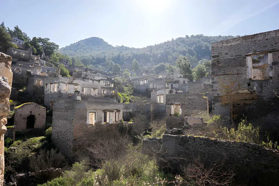
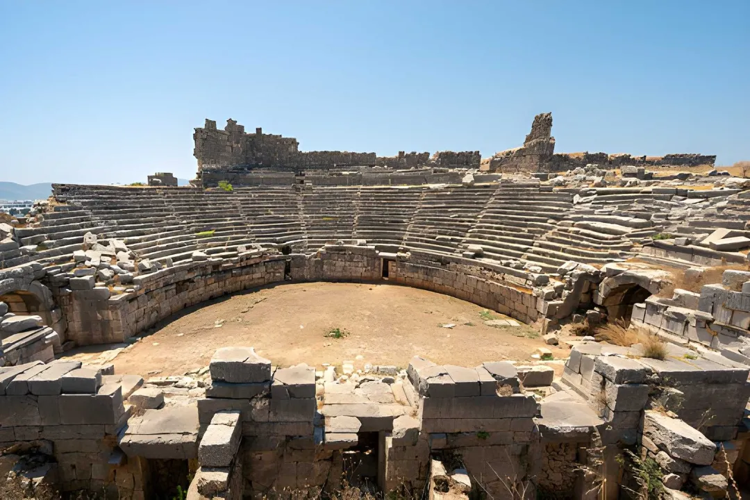
- Kayaköy (Ghost Village) – An abandoned Greek village with stone houses spread across the hillside. It’s one of the most unique historical spots on the route.
- Forest Trail Sections – Shaded walking paths surrounded by pine trees, especially in the early part of the route.
- Panoramic Viewpoints – As you gain elevation, you’ll start to see wider views toward the Ölüdeniz and Ovacık area.
Good to Know
- The route follows the standard Lycian Way markings (red & white)
- Some parts of the trail pass through shaded forest areas
- You may pass small rural areas along the way
- Ovacık is one of the main access points of the Lycian Way
Tips: Start early to keep a comfortable pace. Carry enough water (limited sources on the trail). Wear proper walking shoes due to uneven terrain. Plan short breaks during the walk.
Alerts / Hazards
- Bee-houses are located near higher points – keep a safe distance
- You may encounter local beekeepers in some sections
- Water fountain exists on the route but is often dry
- Carry enough water before starting from Kayaköy / Ovacık
- Some rocky and uneven sections – watch your footing
This stage is one of the most scenic parts of the Lycian Way. Starting from Ovacık, the route climbs along the slopes of Babadağ and continues toward Faralya with continuous coastal views.
Route Details
- Distance: ~12.8 km
- Walking Duration: ~5–6 hours
- Total Day Duration: ~09:00 – 21:00
- Elevation Gain: ~765 m
- Descent: ~735 m
- Difficulty: Moderate to Challenging
- Start: Ovacık (09:00)
- End: Faralya
- Return / Hotel Arrival: Around 21:00
What to Expect
The route begins from the official Lycian Way starting point in Ovacık and gradually climbs along the mountain.
- Long uphill sections, especially in the first half
- Narrow and rocky paths in some areas
- Open mountain trails with steep drops in parts
- Forest sections after higher elevation points
This is a more demanding day compared to Day 1 and requires steady pacing.
Highlights Along the Route
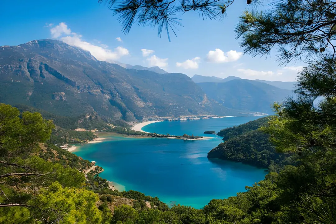
- Ölüdeniz & Lagoon Views – Early in the walk, you’ll get wide panoramic views of Ölüdeniz, including the famous blue lagoon.
- Babadağ Slopes – The route follows the mountain ridge, offering open views of the Mediterranean.
- Gemiler Island (St. Nicholas Island) Views – Visible from higher sections along the trail.
- Mountain & Forest Transition – The route shifts from open panoramic views into more shaded forest areas as you approach Faralya.
Good to Know
- This is one of the most scenic but also more physically demanding sections
- The route follows red & white Lycian Way markings
- Some sections are exposed with steep drops – requires attention
- You may encounter beekeeping areas along the route
- Natural water sources exist but are not guaranteed year-round
Tips: Start early (important for this stage). Carry enough water and snacks. Take breaks during elevation gain sections. Use proper hiking shoes (terrain is uneven and rocky). Keep an eye on trail markings at forks.
Alerts / Hazards
- Take caution in poor weather conditions, especially strong winds
- Weather can change quickly in higher elevation areas
- Some sections are exposed with steep drops – stay focused on the trail
- The path can be rocky and uneven in places – watch your footing
- It may take a couple of days to fully adapt to Lycian Way terrain
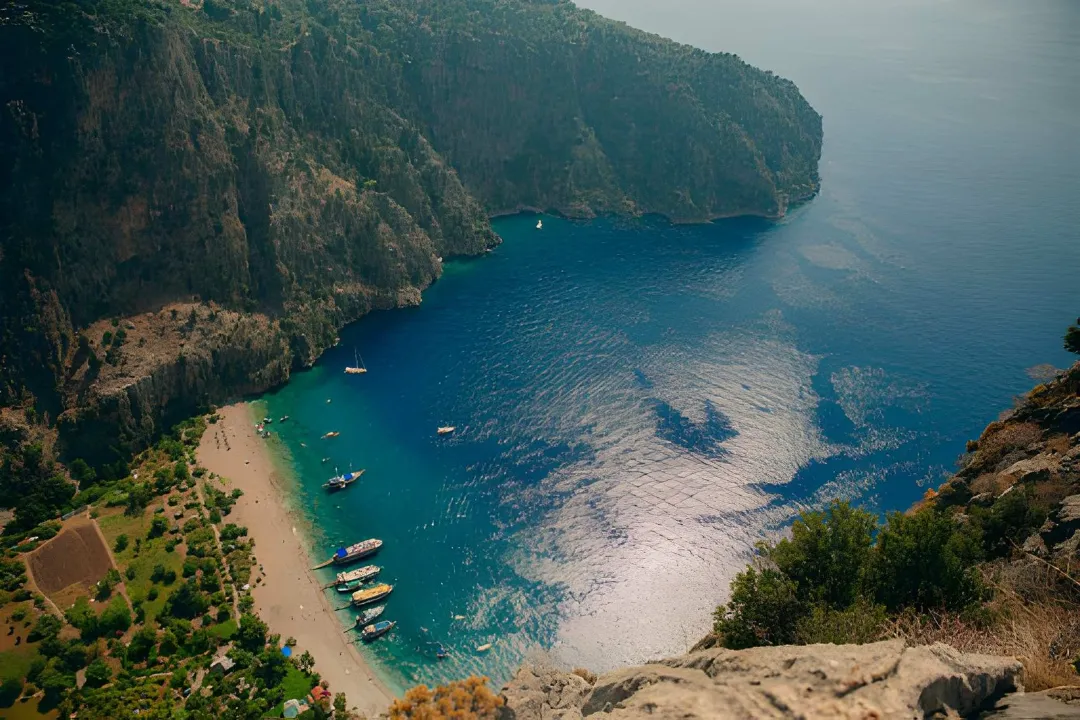
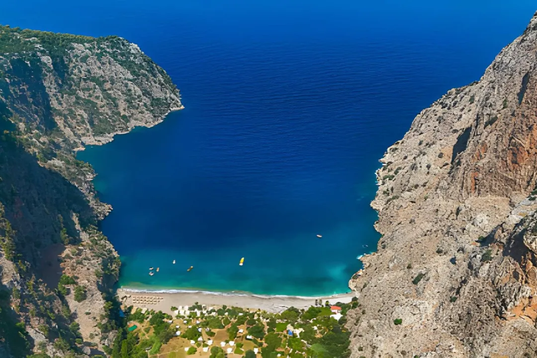
This stage is shorter but very scenic. It connects Faralya to Kabak through forested paths and coastal viewpoints, finishing with a short descent from Kabak village down to the beach.
Route Details
- Distance: ~4.8 km (Faralya → Kabak) + ~1.7 km (Kabak → Kabak Beach)
- Walking Duration: ~2–3 hours + ~1 hour
- Total Day Duration: ~09:00 – 21:00
- Elevation Gain: ~280 m / ~30 m
- Descent: ~355 m / ~260 m
- Difficulty: Easy to Moderate / Easy
- Start: Faralya (09:00)
- End: Kabak Beach
- Return / Hotel Arrival: Around 21:00
What to Expect
The route starts from Faralya and continues along a hilly path toward Kabak, followed by a steady descent to the beach.
- Rolling terrain (up and down sections)
- Forest trails with shaded areas
- Open viewpoints along the coast
- Mostly downhill walking from Kabak village to the beach
- Short but slightly steep in parts near the beach descent
This is a more relaxed walking day after the longer Ovacık – Faralya stage.
Highlights Along the Route
- Butterfly Valley (Viewpoint from above) – One of the most iconic views on the Lycian Way, seen from the cliffs near Faralya.
- Coastal Cliff Views – Continuous Mediterranean views along parts of the trail.
- Forest Sections – Cooler shaded areas before descending toward Kabak.
- Kabak Valley Views – Open views of the valley as you descend toward the coast.
- Kabak Beach – A quiet and natural beach surrounded by cliffs and greenery.
Good to Know
- The route follows red & white Lycian Way markings
- You’ll pass above Butterfly Valley – access is from viewpoint, not directly down
- The trail includes both shaded forest and exposed coastal sections
- Water sources are available in Kabak village before the descent
- The Kabak → beach section is often combined with the Faralya → Kabak stage on the same day
Tips: Take your time at viewpoints – this is one of the most scenic sections. Start earlier if you want to avoid heat on exposed sections. Carry water and light snacks. Take it slow on the descent to the beach.
Alerts / Hazards
- Some sections run close to cliffs – stay on marked paths
- Rocky and uneven ground in parts
- Slippery surfaces possible in hot or humid conditions
- Steep downhill sections toward the beach – watch your footing
- Loose rocks on parts of the trail near the beach descent
This stage is a scenic but more remote section of the Lycian Way. It connects Alınca to Yediburunlar (Gey) and offers wide coastal views with a mix of descents and climbs.
Route Details
- Distance: ~7.7 km
- Walking Duration: ~3.5–4 hours
- Total Day Duration: ~09:00 – 21:00
- Elevation Gain: ~460 m
- Descent: ~560 m
- Difficulty: Moderate
- Start: Alınca (09:00)
- End: Yediburunlar / Gey
- Return / Hotel Arrival: Around 21:00
What to Expect
The route starts from Alınca and continues along a mix of descending and ascending paths toward Gey.
- Initial descent into valley sections
- Gradual climbs back up toward higher viewpoints
- Natural terrain with rocky and uneven paths
- Remote and less crowded compared to earlier stages
This stage feels quieter and more rural, with fewer people on the trail.
Highlights Along the Route
- Yediburunlar (Seven Capes) Views – Wide coastal panoramas with multiple headlands visible along the Mediterranean.
- Valley & Farmland Sections – Transition from mountain paths into greener, cultivated areas.
- Gey Village – A small and traditional village with a local atmosphere.
Good to Know
- Marked with red & white Lycian Way signs
- Considered a more remote and less trafficked section
- Mix of descent and ascent – not a flat route
- Continuous coastal views in several sections
- Gey is a small village with limited infrastructure
Tips: Start early to avoid heat on exposed sections. Carry enough water and snacks. Take breaks during descent and climb transitions. Keep a steady pace – terrain changes frequently.
Alerts / Hazards
- Steep descent sections at the beginning – watch your footing
- Uneven and rocky terrain throughout
- Exposed sections with sun and limited shade
- Remote areas with fewer facilities along the route
This stage moves away from mountain terrain and into a flatter, more open landscape. It connects Letoon to Kınık and passes through historical and agricultural areas.
Route Details
- Distance: ~4–5 km
- Walking Duration: ~1–2 hours
- Total Day Duration: ~09:00 – 21:00
- Elevation Gain: ~120 m
- Descent: ~30 m
- Difficulty: Easy
- Start: Letoon (09:00)
- End: Kınık
- Return / Hotel Arrival: Around 21:00
What to Expect
This is one of the easiest sections of the route.
- Mostly flat terrain
- Dirt roads and open paths
- Walking through fields and rural areas
- Minimal elevation compared to previous days
After several days of mountain hiking, this stage feels more relaxed and straightforward.
Highlights Along the Route
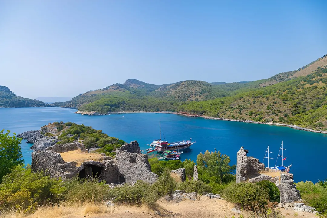
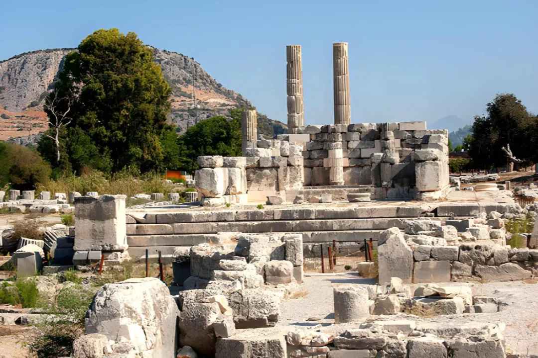
- Letoon Ancient Site – One of the most important religious centers of ancient Lycia, known for its temples and historical significance.
- Xanthos Area (Near Kınık) – The ancient capital of Lycia, located close to the endpoint.
- Rural Landscape – Fields, greenhouses, and local village life along the way.
Good to Know
- This section is mostly flat and easier than previous days
- The trail passes through agricultural land and open areas
- Letoon is a UNESCO World Heritage site and an important historical stop
- Often combined with visits to nearby ancient sites like Xanthos
Tips: Start early to avoid heat. Use sun protection (hat, sunscreen). Carry enough water – limited shade. Take time to explore Letoon before starting.
Alerts / Hazards
- Exposed sections with little shade – sun can be strong
- Hot conditions, especially mid-day
- Limited natural shade compared to previous stages
- Watch for vehicles on dirt or local roads
This stage follows a quieter and more rural part of the Lycian Way. It connects Sarıbelen to Gökçeören through open landscapes, meadows, and small village areas.
Route Details
- Distance: ~11–14 km
- Walking Duration: ~4–5 hours
- Total Day Duration: ~09:00 – 21:00
- Elevation Gain: ~400–450 m
- Descent: ~300–350 m
- Difficulty: Moderate
- Start: Sarıbelen (09:00)
- End: Gökçeören
- Return / Hotel Arrival: Around 21:00
What to Expect
The route starts from Sarıbelen and continues through a mix of open terrain and rural paths toward Gökçeören.
- Rolling terrain with gradual climbs and descents
- Open meadows and farmland
- Sections with forest and scattered trees
- Quiet and less crowded trails
Compared to earlier coastal days, this stage feels more inland and local.
Highlights Along the Route
- Open Meadow Views – Wide landscapes with fewer trees and open skies.
- Local Village Life – Encounters with small farms, shepherds, and traditional rural settings.
- Mediterranean Views (from higher points) – Occasional distant sea views from elevated sections.
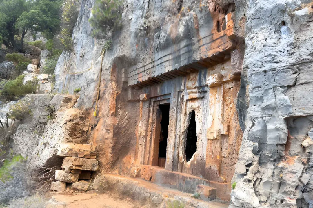
- Rock Formations & Lycian Tombs (near Gökçeören) – Historical rock structures can be seen closer to the endpoint.
Good to Know
- The route follows red & white Lycian Way markings
- More rural and less touristic compared to earlier stages
- Water sources may be available in villages, but not consistent along the trail
- Gökçeören is a small and quiet village
Tips: Start early to avoid heat. Carry enough water and snacks. Take breaks in shaded or village areas when possible. Keep track of trail markings, especially in open terrain.
Alerts / Hazards
- Exposed sections with limited shade – sun can be strong
- Rocky and uneven terrain in parts
- Trail markings require attention in open areas
- Limited facilities along the route
This final stage is a short coastal walk starting from Kaş and ending at Limanağzı. It offers scenic sea views and a relaxed finish to the Lycian Way experience.
Route Details
- Distance: ~4.1 km
- Walking Duration: ~1.5 hours
- Total Day Duration: ~09:00 – 21:00
- Elevation Gain: ~130 m
- Descent: ~125 m
- Difficulty: Easy to Moderate
- Start: Kaş (09:00)
- End: Limanağzı
- Return / Hotel Arrival: Around 21:00
What to Expect
The route starts from Kaş and follows the coastline toward Limanağzı.
- Rolling coastal paths with small ups and downs
- Some narrow and rocky sections
- Open sea views almost throughout the walk
- Short and manageable distance
This is an easier and more relaxed final day compared to previous stages.
Highlights Along the Route
- Kaş Coastal Views – The route starts with wide Mediterranean views, with changing angles of the coastline as you move along the trail.
- Rocky Coastal Path – A natural shoreline path with rocky and uneven sections, typical of the Lycian Way terrain.
- Hidden Coves & Viewpoints – Along the way, you’ll pass smaller bays and quiet viewpoints that feel more isolated and less accessible.
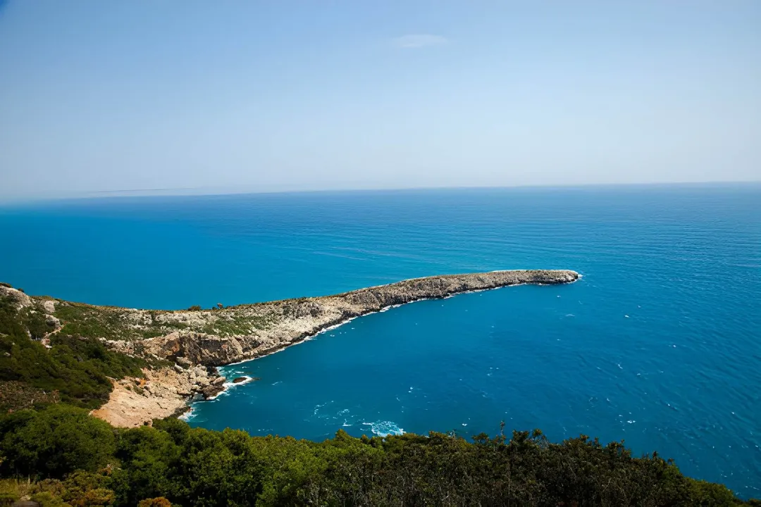
- Limanağzı Bay – The walk ends at Limanağzı, a calm bay surrounded by cliffs and greenery, accessible mainly by foot or boat.
Good to Know
- The route follows red & white Lycian Way markings
- Short distance – can be completed at a relaxed pace
- Some sections are slightly rugged despite the short length
- Limanağzı is not directly accessible by road – usually reached by foot or boat
Tips: Take your time – this is a scenic final walk. Good day for photos and slower pacing. Wear proper footwear despite the short distance. Plan breaks along coastal viewpoints.
Alerts / Hazards
- Some narrow sections with steep drop-offs – stay on marked paths
- Rocky and uneven terrain in parts
- Trail can be slippery in dry dust or after rain
- Pay attention near coastal edges
Distance & Duration
- Daily walks range between 5–13 km.
- Walking time is usually between 2–5 hours depending on the stage.
Terrain
- Forest paths
- Rocky trails
- Coastal routes
- Some uphill and downhill sections
Difficulty
- Moderate level. Suitable for beginners with basic fitness.
Trail Conditions
- Marked routes (red & white signs)
- Natural terrain (not paved)
- Some uneven sections


